We had heard about the middle-aged Italian bicyclist the night before so when we spotted a lone cyclist on the Inuvik-Tuktoyaktuk Highway (ITH) the next afternoon, we suspected it was him.
Apparently, he had ridden the long 3,600-kilometre haul by bicycle from Vancouver to Canada’s Northwest Territories last year in hopes of reaching Tuktoyaktuk, a centuries-old community east of the Mackenzie Delta on the Arctic Ocean.
His plan was to be one of the first to ride the ITH that opened last November, but he was too early. He was at it again this summer to finish off the quest.
We pulled up beside him and Lisa offered a ‘Ciao’ out the window.
As is the case with most people who spend a lot of time alone on the road, the Italian had plenty to say. I understood nothing but Lisa, who knows the language, said he mentioned pitching a tent each night and sleeping in random places along the road. We wondered about the animals in the northern wilderness.
“The animals do their thing. I do mine.”
Lisa and I had driven from Inuvik to Tuktoyaktuk 15 years ago in the dead of winter. We used an ice road through the Mackenzie Delta that continued east along the Arctic Ocean to Tuk which was the only way to drive there. For some of the spring, summer and into the fall the hamlet of 900 souls was cut off from ground transport.
With the opening of the ITH last November, flights to Tuktoyuktuk have been scaled back and the ice road doesn’t get constructed like it had been for years. This summer the people of Tuktoyaktuk see campers, motorcycles, the odd transport truck and, of course, people like the Italian cyclist pulling into town and staring out over the Arctic Ocean into the Polar abyss.
For the first time ever, one can drive, ride or even walk to Canada’s third coast on an all-season road. From coast to coast to coast is a new mantra for Canadian and global road trippers.
Lisa and I could have driven all the way there. Just motor west to Edmonton, Alberta. Then head north on Hwy 43 to Mile Zero of the Alaska Highway at Dawson Creek and continue north to Whitehorse, Yukon Territory.
After Whitehorse, hang a right up the Klondike Highway 530 kilometres almost to Dawson City, then another right up the gravel Dempster Highway 735 kilometres to Inuvik. That section crosses the Arctic Circle and involves two short seasonal ferries. Total distance is a mere 8,000 kilometres from Halifax.
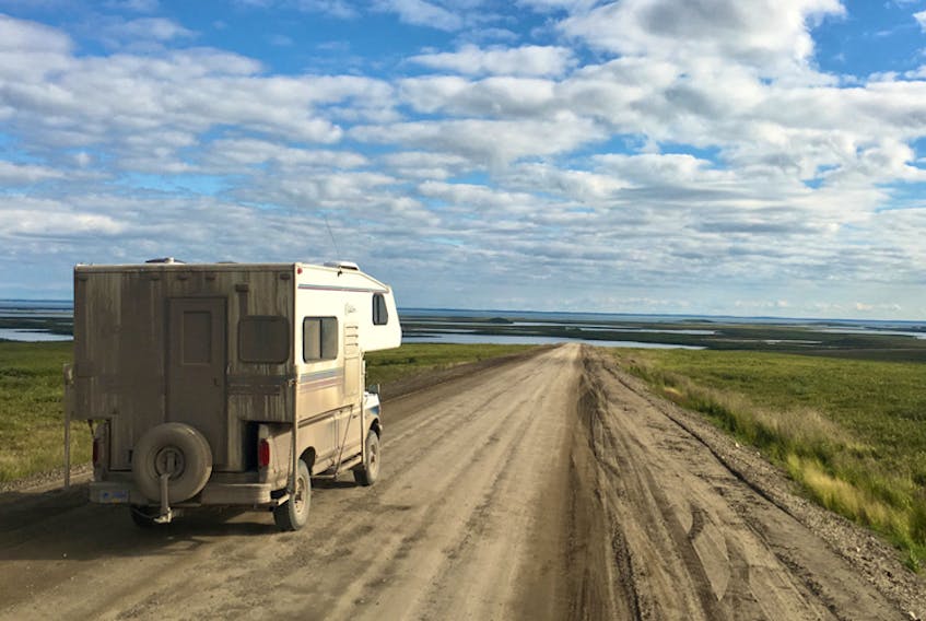
We didn’t have time to do all that, so we flew to Inuvik, rented a pick-up truck and drove to Tuktoyaktuk.
The ITH is an engineering marvel for a few reasons. It is built on permafrost and meanders across Arctic highlands, through an area of glistening lakes and onto the barrens. Travellers cross the tree line halfway then drive across tundra to the Arctic coast.
A project of this magnitude in the high Arctic had never been undertaken without cutting into the permafrost. Per kilometre, it is one of the world’s most expensive roads. Known as ‘a beast of a project’, the two-lane, packed gravel highway was built over four years in the cold, dark winter in order to protect the permafrost and the tundra.
The road travels through the grazing range of the North’s only herd of domestic reindeer that have grazed in the area since the 1930s, crosses the habitat of three caribou herds and reaches the world’s largest cluster of ice-cored Pingos, a national landmark on the outskirts of Tuk.
Although unpaved, the road is hard-packed and smooth, without a lot of loose flying gravel.
It took two and a half hours to reach Tuktoyaktuk where, under a striking blue Arctic sky, life was buzzing. There was a collection of campers parked around a spanking new Arctic Ocean sign along with some mud and dirt-covered motorcycles.
In just a few minutes, we met people from India, Newfoundland and California all wanting to cash in on the ability to drive to Canada’s third, and often forgotten, coast.
The local convenience store sold fuel, clothing, food, bicycles and pretty much anything one would need in limited quantities, even couches. The hamlet’s baseball field was packed, and the local ball team was slugging it out with a team from Inuvik. Laughing children scooted around on bicycles, oblivious to the many visitors.
The sun wouldn’t set until midnight in late August and time seemed to stop for Lisa and me.
Driving back to Inuvik, the ‘escaped’ feeling became more intense. We were not in a place where an element of danger loomed. We didn’t have to ensure our papers were in order to be scrutinized by a dubious foreign government official.
The stark Arctic beauty was dazzling so we slowed down and puttered along savouring the tranquillity, awe and open sky that is the North.
We didn’t see the Italian cyclist though. He must have set up camp on the tundra somewhere doing his thing while the animals did theirs.