Through a partnership with Google, the Nature Conservancy of Canada has photographed and mapped 18 of its most spectacular natural areas across the country, including its property along the Pugwash Estuary, and the results were recently posted on NCC’s website and Google Street View.
“It allows people who many not be that mobile, or able to get out and walk on the trail, to see what they might see from the trail on their screen,” Doug Van Hemessen, Nova Scotia Stewardship Co-ordinator for the Nature Conservancy of Canada, said. “It’s also good for someone who may live on the other side of the world or the other side of the country. They may have heard about our trail and wondered what the trail looks like.”
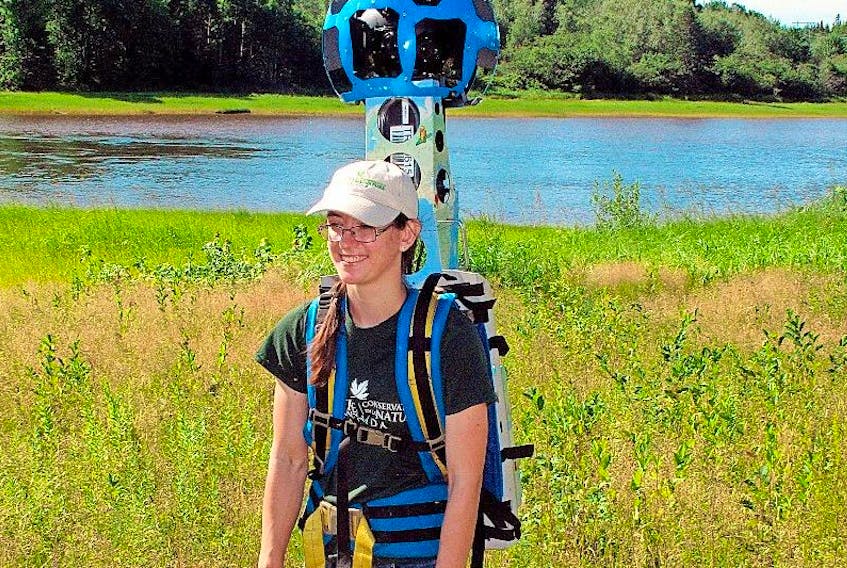
For the past two summers, Nature Conservancy of Canada staff have walked many of organization’s most popular trails with the Google Trekker, a 29-kg backpack-mounted 360-degree camera system.
The Google Trekker’s 15 cameras take images every 2.5 seconds, giving viewers a realistic look at the trail and surrounding scenery. It not only captures images of the trails, it connects those images to GPS locations, enabling would-be hikers to plan trips to the trails once they’ve previewed them virtually.
The Pugwash Estuary is one of the biggest and most intact estuaries remaining on the Northumberland Strait with little shoreline development along the water and the saltmarsh.
“There is a lot of intact natural area there that provides a great habitat for wildlife and nature,” he said. “It’s also an opportunity for people to go an experience that environment.”
The estuary has also been the source of a lot of conservation work in recent years including efforts to remove the invasive Glossy Buckthorn plant, an annual event done in conjunction with the Friends of the Pugwash Estuary.
Van Hemessen said the project also gives NCC the opportunity to profile the new loop trail that runs through the property that was built with the help of the Friends of the Pugwash Estuary.
“It’s a great marketing tool, not only for the virtual ability to walk the trail but it’s also a communications tool we can use as well,” Van Hemessen said.
Several NCC sites across Canada have been captured through the trekker. The complete list of NCC sites can be viewed at http://www.natureconservancy.ca/trekker.
“We hope these images will excite people in Canada and around the world to explore some of our most stunning and diverse landscapes, coast to coast,” said John Lounds, president and CEO of the Nature Conservancy of Canada. “Our mandate is to conserve our precious places, connect Canadians to nature and inspire people to cherish and care for all that nature gives us. We are pleased to work with Google to bring these conservation areas to a wider audience”.
A second Nova Scotia site, NCC’s coastal trail at Gaff Point, near Lunenburg, is also viewable online.
[email protected]
Twitter: @ADNdarrell
Experiencing the Pugwash Estuary online
PUGWASH – The Pugwash Estuary Trail can now be experienced by anyone around the globe without ever going to Pugwash.
STORY CONTINUES BELOW THESE SALTWIRE VIDEOS