FORT LAWRENCE, N.S. — Protecting expensive infrastructure from rising seas and possible storm surges could be a multi-faceted approach and include more than building dikes higher or moving highways or railways.
TransCoastal Adaptations, led by Saint Mary’s University researcher Dr. Danika van Proosdij and CBWES Inc. president Tony Bowron, has another solution it feels could be part of the toolbox.
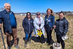
Representatives from that organization were in Fort Lawrence near Amherst on Tuesday to officially launch the Converse Marsh Managed Realignment Site.
“The aim of the project is to leverage some of the capacity of tidal wetlands to create new habitats to self-engineer in an environment where they’re actually moving dikes further back in a particular area,” said van Proosdij, a Saint Mary’s professor and chair of the university’s department of geography and environment studies.
The Converse Marsh site is tucked just inside the Nova Scotia border along the Missaguash River that separates the province from New Brunswick. It’s not far from the Beaubassin national historic site.
Tidal wetlands, such as salt marshes, form the first line of defence during severe storm events, but the vast majority of these ecosystems have been lost due to diking, coastal development and tidal barriers like causeways.
By realigning sections of existing dikes and restoring the natural hydrology and habitats, the team is able to better protect coastal infrastructure as the climate change risk makes the dikes, and the infrastructure they protect from the sea, more vulnerable.
The project started in 2016 with support from the National Wetlands Conversation Fund through Environment and Climate Change Canada and the provincial Agriculture Department. It was determined there was a section of dike that was rapidly eroding.
“One of the ways to address that was to move it back and strategically realign the dike in that area and allow new marsh to grow where water has been restored,” she said. “It’s a practice that has been used in other areas of the region but is a widely approved method for dike management in Europe.”
Working with Agriculture, a kilometre of dike was moved back or flattened and an aboiteau removed to allow a tidal zone to return in December 2018. It covers 15.4 hectares.
“The change we have noticed is that we’re starting to have a lot of sediment coming into that area that’s providing that first foundation where plants are establishing themselves and starting to show signs of new salt marsh habitat growth,” she said.
van Proosdij said sites for the Making Room for Wetlands project were chosen based on the vulnerability of the existing dike and ensuring minimal impact to landowners and users. Focusing on sites where dikes can no longer be maintained allows the team to address potential risks associated with climate change such as storm surge and flooding.
“This initiative stands on the shoulders of 20 years of research and projects to restore tidal wetlands throughout the province, which has led to our increased understanding of the form, function and importance of these systems, particularly in the face of climate change and sea level rise and the role these systems can play in providing the first line of defence for our coastal infrastructure and communities,” Bowron said. “It demonstrates we have options besides the traditional engineering approach of building barriers bigger. We have more tools in the toolbox to address the challenges climate change and sea level rise are presenting us with.”
The Converse Marsh realignment, he said, can provide examples of what can be done to ease the burden and the intent is not to tell the province to move all dikes back. Instead, there are win-win situations around the province in which strategically moving the line of defence back can ensure the maintenance or improved protection of critical infrastructure and restoring natural systems like salt marshes.
For a lot of low-lying communities, he said, 2050 is the litmus test while for others it’s 2100. While it may seem like a long way off, 2050 and 2100 will arrive quickly.
“A lot of communities are already facing the challenges of sea level rise as well as the increasing frequency and severity of storms,” he said. “The decisions and actions we’re taking today will shape what our coastal communities look like for the next 50-plus years.
“Part of this is we need to take a moment and decide what we want our coastal communities to look like. We grew up being able to walk right down to the beaches or visit the marshes for birdwatching or hunting. I, for one, hope my son will have a similar opportunity, but if we don’t have that conversation, those opportunities won’t be there and he won’t enjoy that because our coast will be a rock wall.”
Part of the work in Fort Lawrence is to help develop a framework for implementing nature-based climate change adaptation strategies. It will become a demonstration site showing how to decrease the vulnerability of dikes.
“We’re hoping that as we consider how we address vulnerability of the dikeland system in the isthmus that managed realignment is one of those tools that can be used to address some of those challenges,” van Proosdij said.
Funding for the Fort Lawrence project has been provided by the federal Department of Fisheries and Oceans Coastal Restoration.
Ducks Unlimited completed a similar dike realignment project across the border in Aulac, N.B. in 2010, while TransCoastal Adaptations has a similar project on the Cornwallis River near Kentville.